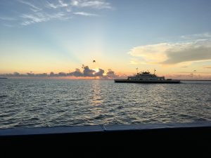
Did you know that ferries are used to monitor water quality?
North Carolina Department of Transportation (NCDOT) ferries that cross the Neuse River and Pamlico Sound estuaries are collecting water quality data as part of a unique program called “FerryMon”. These ferries are tracking the health of the nation’s second largest estuary and North Carolina’s most important fisheries and recreational resource via automated water quality monitoring systems.
Data is collected and downloaded to the UNC-Chapel Hill marine laboratories in Morehead City, where it is processed and made available to state and federal environmental and fisheries agencies, educational institutions, and public and private outreach sources. Information is used to determine water quality effects of events such as storms, hurricanes, nutrient and pollution discharge, and to establish a database which can monitor water quality status and trends. Most importantly, FerryMon data is used to determine the essential ingredients for long-term environmental management and protection of Pamlico Sound’s precious resources.
Click here for the Neuse River Ferry Crossing Real Time Data
***Past data must be requested and is not available online currently
Click here to view a Time-Warner video produced to describe FerryMon monitoring
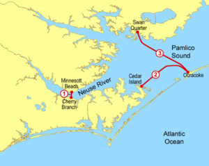
Locations
FerryMon operates on two NCDOT ferries, the M/V Neuse (route 1) and the M/V Carteret (routes 2 & 3).
As of 2019, routes 2 & 3 are unable to collect data & as of April 2021, route 1 is down for Ferry maintenance.
Where are the Ferries currently? Check their live locations from a Ferry Captains Point of View Every 3 min:
Neuse River (M/V Neuse on Route 1)
Pamlico Sound (M/V Carteret on Routes 2 or 3) CURRENTLY NOT ACTIVE
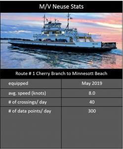
The M/V Neuse operates along the Neuse River (Route #1)
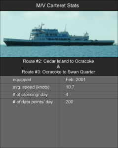
The M/V Carteret primarily operates along the Cedar Island to Ocracoke route (#2), but also operates along the Swan Quarter to Ocracoke route (#3).
Methods
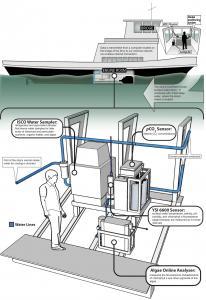
A portion of the ferries’ intake water is diverted, analyzed and measurements recorded on an on-board computer. A Digital Global Positioning System (DGPS) is linked to the computer to log measurement locations by date, time, latitude and longitude. Logged data is downloaded via wireless internet connection and added to the PostgreSQL database.