DATA QUALITY
ModMon is a proven source of high-quality, readily-available, verifiable water quality data compatible with State and federal agency informational data bases, meeting EPA QA/QC specifications. ModMon also serves State and federal agencies (EPA, NOAA, NASA) as a ground-truthing data source for aircraft and satellite-based remote sensing of chlorophyll, turbidity and harmful algal blooms. Nationally and internationally-respected scientific reports and publications in top quality journals have used ModMon data and can be found here.
ModMon continues to be a timely, trustworthy and productive partner for obtaining and evaluating water quality data for State and federal agencies, as well as municipalities, private industry and citizen/stakeholder groups. ModMon serves a technically-sound and effective third party in the event of conflicting recommendations among the State and federal agencies as management strategies are further developed and revised.
LONG-TERM MONITORING NEEDS
Human expansion in and growing use of the Neuse watershed, combined with a multi-decadal increase in tropical storm and hurricane activity (7 major hurricanes in the past 6 years) calls for a comprehensive, long-term assessment of water quality impacts. For State modeling and management purposes, it is critical to differentiate human from natural (climatic) drivers of water quality. Many impacts are episodic, necessitating rapid access to and evaluation of water quality and habitat responses. Because its scientific expertise and laboratories are located near the estuaries, ModMon has been effective in rapidly and intensively respond to these events. Examples include documenting the initial and longer-term impact of Hurricane Floyd’s (1999-2000) floodwaters on water quality and habitat condition in the Neuse-Pamlico Sound system. Hydrologic and water quality effects from more recent Hurricanes Isabel (2003) and Ophelia (2005) have also been documented and serve as a long-term data baseline for quantifying and comparing human (e.g. nutrient and other pollutant inputs) and climatic pressures and perturbations on North Carolina’s most important aquatic resource.
EDUCATIONAL APPLICATIONS
ModMon’s dataset, sampling locations, and researchers are utilized as part of the MASC 220 (ENST 220) North Carolina Estuaries: Environmental Processes and Problems MAYMESTER course offered through the EMES Department at UNC Chapel Hill. This class has used the Neuse River estuary as a case study to examine both natural processes and human impacts on estuarine systems. The course is heavily “hands-on” and blends environmental modeling, field research, laboratory analysis, and data synthesis and interpretation. Suitable for both science and non-science majors, students spend one week at the Institute of Marine Sciences (IMS) in Morehead City. When not conducting field work, students work on laboratory analysis, data synthesis, and group reports and have afternoon seminars conducted by IMS faculty and graduate students.
HISTORICAL COMPONENTS (FALL 2005)
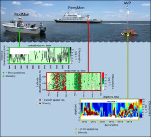
ModMon is the main source of data for calibration, verification and validation of water quality models being used to adaptively test and manage the Total Maximum Daily Load (TMDL) for the Neuse River Estuary (NRE). It is designed for both “event-based” and long-term intensive monitoring. To fill NC-DEQ’s needs for optimal vertical resolution of water quality criteria needed to evaluate the Total Maximum Daily Load (TMDL), ModMon has been involved in the deployment and calibration of automated vertical profilers (AVPs). The AVPs produce depth profiles on chlorophyll-a and other critical water quality indicators, including turbidity, dissolved oxygen, salinity and temperature, by using in-stream sensors. This, combined with the ModMon sampling throughout the Neuse R. Estuary and the NC Ferry based water quality monitoring program, FerryMon, provide the quality and quantity of data as well as the statistical procedures necessary for making scientifically sound evaluations of the TMDL.
 The long-term effectiveness of the legislatively-mandated 30% reduction in nitrogen loading to reduce symptoms of eutrophication (nuisance algal blooms, hypoxia and fish kills) is evaluated with ModMon data. Validations of the NEEM, Neu-BERN and EFDC (EPA) water quality models have relied almost exclusively on ModMon monitoring data. Additionally, some models require rate (i.e., algal growth, nutrient cycling, productivity) measurements, which ModMon routinely provides. Continued modeling will be required to adaptively manage TMDLs into the foreseeable future and will continue to rely on ModMon WQ monitoring data.
To fill DENR’s needs for optimal vertical resolution of water quality criteria needed to evaluate the TMDL, ModMon had (Fall 2005) been involved in the deployment and calibration of automated vertical profilers (AVPs). These profilers collected high resolution continuous data on Chlorophyll a (Chl a ) and were located in segments of the estuary that have historically shown symptoms of nutrient impairment. The AVPs produced depth profiles on chl-a and other critical water quality indicators, including turbidity, dissolved oxygen, salinity and temperature, by using in-stream sensors.