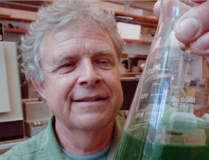
After ModMon sample collections, Dr. Nathan Hall (UNC-IMS) summarizes the data collected via sonde and any visual observations. Profiles are also created along the sampling stations.
2024
Hi all,
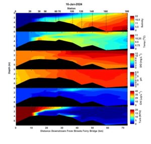
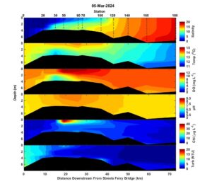
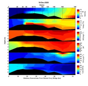
Starting Christmas Eve, several strong cold fronts produced significant rainfall in the Neuse River watershed and river flows peaked over 8000 CFS prior to sampling on 16 January 2024. The high river flow completely freshened the estuary upstream of New Bern (stations 0 and 20) and surface waters were fresh downstream to station 60. Surface water at station 180 was only about 15 where it had been about 20 a month earlier. The estuary was strongly stratified with surface to bottom salinity differences of 5-7 along the estuary from New Bern to the mouth. Water temperature was 8-10 C throughout the estuary. Chlorophyll was less than 15 ug/L throughout the estuary with highest levels of ~ 15 ug/L occurring as a broad surface maximum from stations 60 to 140. High river flows caused high turbidity (>20 NTU) at the upper stations (stations 0-30).
2023

A few rain events in late November increased river flow at Kinston from less than 400 CFS in mid-November to 2400 CFS by Thanksiving, a value near the seasonal average. On 6 December 2023, the estuary was still very salty but surface waters above New Bern were significantly freshened and bottom water salinity at station 0 was back to its normal freshwater condition. The estuary was strongly stratified with surface to bottom salinity differences of 13 to 5 from above New Bern to the Mouth. Cooler (10-14 C) water temperatures prevented bottom water hypoxia. Chlorophyll was less than 15 ug/L throughout the estuary.
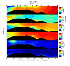
Other than a decline of water temperature by another 2-3 C down to 15-16C, conditions on 6 November 2023 were very similar to those on 9 and 24 October. The estuary was very salty and moderately stratified. Bottom water salinity at the head of the estuary increased to 10, ranking in the top 5 of salinity measurements at that location. Chlorophyll was generally less than 10 ug/L but again there was a small zone of elevated chlorophyll (30-40 ug/L0 at the surface at station 20. Microscopy revealed it was the same non-toxic dinoflagellate, Levandarina fissa, that had been observed blooming at station 20 on 9 and 24 October. The bloom was positioned at the leading edge of the freshwater plume and highest biomass was just slightly below the surface. The combination of consistently low flows (400-800 CFS from 9 October to 6 November 2023) and the ability of the motile dinoflagellate to take advantage of the riverine nutrients and minimize downstream advection through vertical migrations probably had something to do with its persistence at this upstream location over the past month.
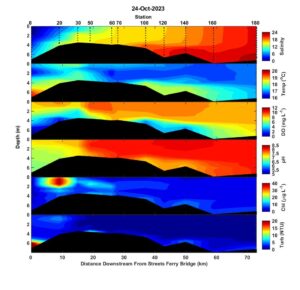
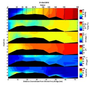
Conditions on Oct 24th were very similar to those on Oct. 9. The estuary as a whole was still unusually salty and bottom waters at station 0 still had a salinity of 8. Water temperatures were a couple of degrees cooler with surface temperatures ranging from about 16 to 18 and bottom waters a couple of degrees warmer (18-19). Surface to bottom salinity differences ranged from 8 at the head of the estuary to about 4 at the mouth. The most upstream stations (0 and 20) had hypoxic bottom water. Again, chlorophyll values were generally less than 15 ug/L with the exception of a bloom at station 20 where chlorophyll was greater than 40 ug/L. The bloom was still dominated by the non-toxic, warm weather bloom forming dinoflagellate, Levandarina fissa (a.k.a. Gyrodinium instriatum).
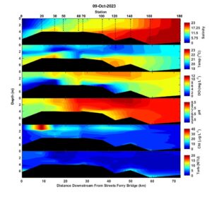
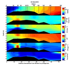
On Oct. 9, the estuary was still very salty with downstream salinity greater than 20. Bottom water at station 0 (usually freshwater) had a salinity of 8 which is in the top ten highest ModMon salinity measurements. Temperature ranged from about 19-22 C with warmer and saltier waters along the bottom. The upper estuary above New Bern and near the bend (stations 100 and 120) had hypoxic bottom waters. Chlorophyll concentrations were less than 15 ug/L except a small surface bloom at station 20 where chlorophyll fluorescence was greater than 40 ug/L. Microscopic examination of surface water from station 20 revealed a phytoplankton community dominated by the warm season dinoflagellate, Lavanderina fissa (a.k.a. Gyrodinium instriatum). It’s the most common bloom former during the warmer months in the Neuse and is not known to produce toxins.
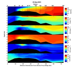
High salinity continued on 25 September 2023 with downstream salinity near 25. The estuary was moderately stratified and water temperatures were much cooler (20-24 C) due to the passage of our first early fall cold front. Bottom water dissolved oxygen conditions were much improved from earlier in September with the only zone of hypoxia confined to the region near New Bern (station 30). Chlorophyll values were generally less than 10 throughout the estuary with the exception of a small zone of elevated (15-30 ug/L) at stations 30 and 50.
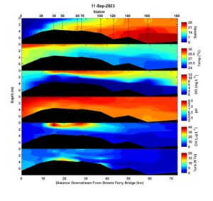
On 11 September 2023 the estuary continued to be extremely salty. Bottom water salinity at station 180 in the lower estuary was 28, the fourth saltiest salinity measurement in the 28 year record for that station. Surface waters greater than 15 extended upstream to about where the estuary widens at stations 60 and 70. Water temperatures ranged from about 30 C at the surface upstream in the estuary to about 25 C in the bottom waters near the mouth. The estuary was strongly stratified and bottom waters were hypoxic from above New Bern at station 20 to the mouth at station 180. A zone of elevated surface chlorophyll (30-40 ug/L) was observed from stations 30 to 70. Microscopic observation of station 60 surface water indicated that the bloom was composed of a mixed assemblage of cryptophytes, dinoflagellates, and diatoms. The icthyotoxic dinoflagellate Karlodinium veneficum was abundant (~500 cells/mL) but fish kills usually aren’t observed until concentrations reach about ten thousand cells/mL.
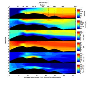
On 25 July, water temperatures throughout the estuary were in the high 20s which is normal for late July. The estuary was still strongly stratified and bottom waters were hypoxic from station 30 to the mouth. A zone of elevated chlorophyll (25-30 ug/L) was detected in the bottom waters of stations 60 and 70. Elevated bottom water chlorophyll a is common in winter and spring but less so in summer, prompting further examination. A look under the microscope at station 60 bottom water showed high concentrations of the mixotrophic (eats other phytoplankton) dinoflagellate, Pheopolykrikos hartmannii. It’s a huge cell packed with pigments which explains the peak in chlorophyll. It is not known to cause any problems.
I hope everyone has a safe end to the summer, and that we’re spared from storms.
Best,
Nathan
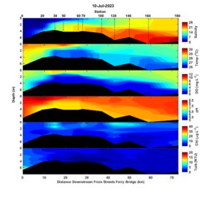
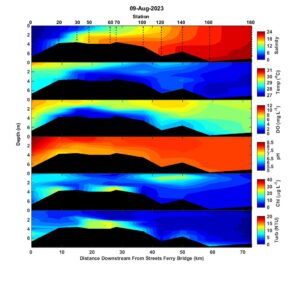
By 10 July, surface water temperatures were in the high 20s and bottom waters were 26-28 C. Salinity based stratification was strong with surface to bottom differences that ranged from greater than 10 from stations 20 to 70 to about 5 further downstream. Bottom waters were hypoxic from stations 20 to the mouth at station 180. Chlorophyll was mostly less than 10 ug/L with a few zones up to 15 ug/L between stations 30 and 140. Turbidity was less than 5 NTU except on the bottom at station 0 where turbidity was ~10 NTU.
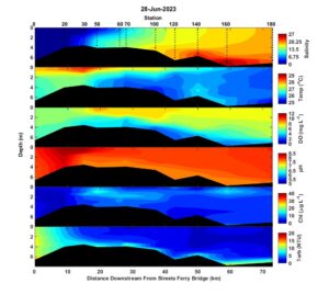
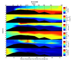
By 28 June, water temperatures had climbed into the mid 20s throughout most of the estuary. Again, there was only moderated salinity-based stratification. Bottom waters were not hypoxic and chlorophyll concentrations were low (5-15 ug/L). Elevated turbidity (>10 NTU) at the head of the estuary was caused by elevated river flows. Turbidity was also elevated at the bottom along the entire transect but the cause isn’t clear.
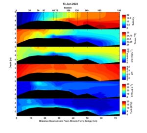
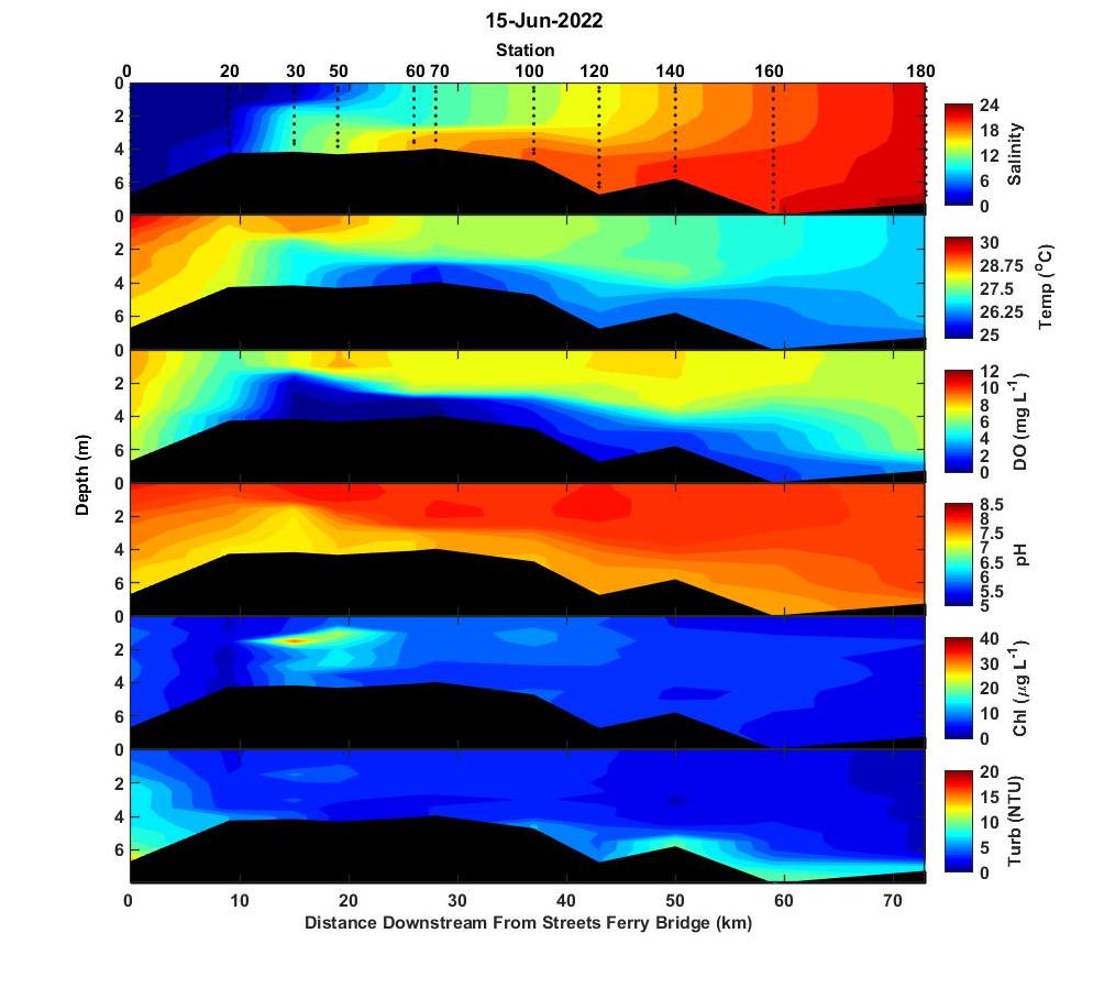
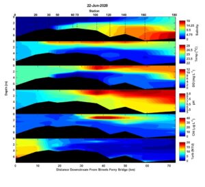
We had an unusually cool June and that was reflected in water temperatures that were still mostly in the low 20s on 13 June. Stratification was again moderate with surface to bottom differences that ranged from 1-4. Bottom water oxygen was about 4 mg/L throughout most of the estuary and only station 60 had hypoxic bottom water conditions. Chlorophyll a was less than 15 ug/L throughout the estuary.
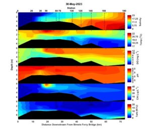
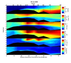
On May 30, salinity-based stratification was moderate with top to bottom differences of about 5. Water temperatures were still less than 20 C throughout most of the estuary and bottom waters were well oxygenated. A zone of elevated chlorophyll extended from station 50 to 100 with a surface peak at station 50 that was about 40 ug/L. Microscopic examination showed a community dominated by a euglena, Eutreptia lanowii I believe, and a mix of diatoms and cryptophytes. None of these are known problem makers.
Hi all,
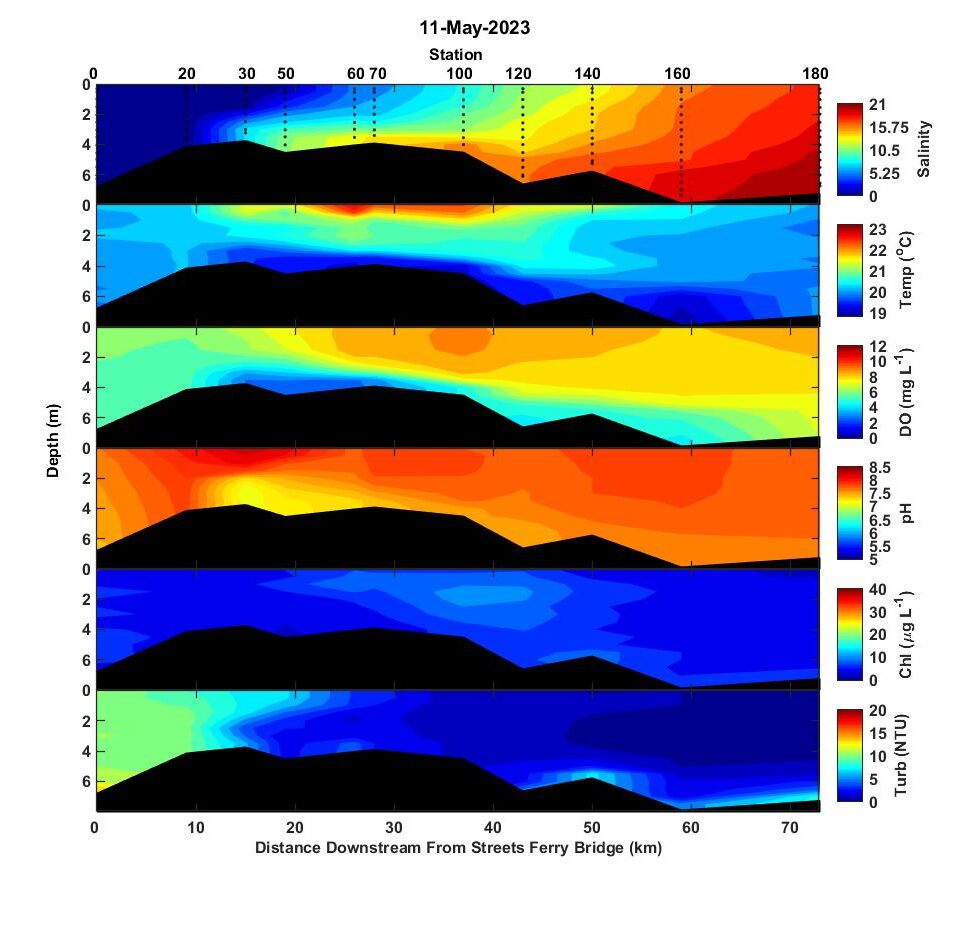
I hope everyone is enjoying the start of summer. River flow over the month prior to the 11 May 2023 sampling trip was about twice the seasonal norm. The tip of the salt wedge was near New Bern and the lower estuary is still saltier than normal at a salinity of ~20. Strong salinity based stratification was reinforced by temperature gradients with bottom water temperature 2-4 degrees cooler than the surface. Bottom water dissolved oxygen was 4-6 mg/L along most of the transect but dipped to near hypoxic (<2 mg/L) near the tip of the salt wedge at stations 30 and 50. Chlorophyll was less than 10 ug/L throughout the estuary and only approached 10 ug/L within a broad mid-estuary maximum between stations 60 and 140. High river flows caused elevated turbidity (~10 NTU) in the river water entering the estuary.
Best,
Nathan
Hi all,
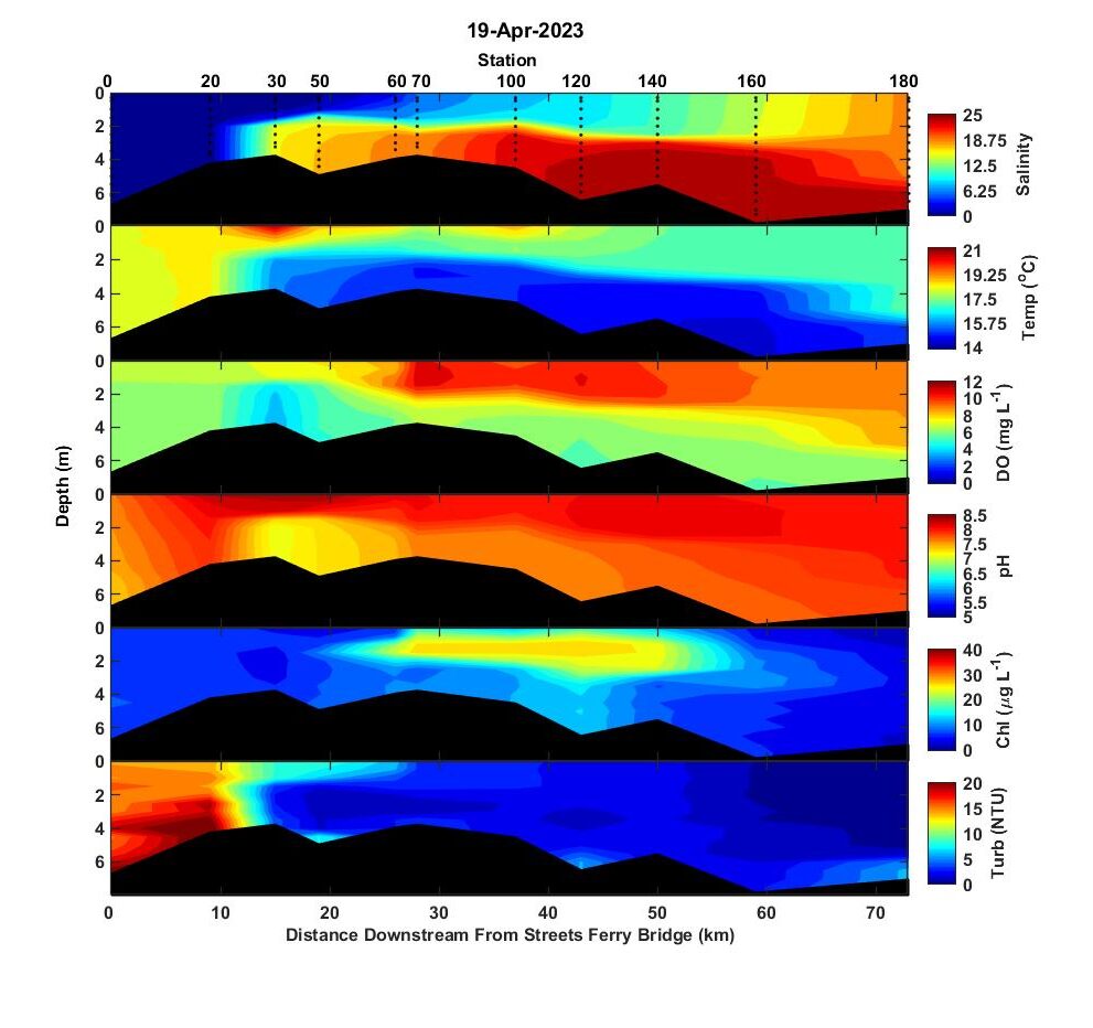
The winter and early spring saw flows that were always below normal and usually only about half of the seasonal norm. That changed starting on 10 April when flows began to rapidly increase. By the time of sampling 19 April, flows peaked at nearly twice the seasonal norm. Dumping that much freshwater into a really salty estuary caused very strong salinity based stratification with surface to bottom salinity differences of ~15 in the upper estuary from station 30 to station 120 and ~10 further downstream. Bottom waters were cool (< 15 C) and certainly the low temperatures helped prevent bottom water hypoxia. High turbidity (>10 NTU) flood water penetrated downstream to station 60 and turbidity was < 5 NTU throughout the rest of the estuary. A large mid-estuary chlorophyll maximum (> 20 ug/L) was observed from station 60 to 140 and was concentrated vertically just above the pycnocline at ~1.5 m depth. Microscopic examination of station 100 surface water revealed that small solitary centric diatoms and chain-forming centric diatoms were the dominant taxa. There was a relatively high concentration (~1000 cells/mL) of the toxic dinoflagellate, Karlodinium veneficum. Although 1000 cells/mL is higher than normal, Karlodinium doesn’t usually cause fish kills until the concentrations reach about 10,000 cells/mL.
-Nathan
Hi all,
Despite a few rain events, river flows in late March and the first few days of April were still only about half their seasonal norm. The recent freshwater inputs lowered surface salinity values to less than 2 upstream of station 70. The tip of the salt wedge was still upstream of New Bern and bottom waters of the lower estuary were still greater than 20. The estuary was strongly stratified with vertical salinity differences greater than ~5 and temperature differences greater than ~3 C along most of the estuary. A small zone of very salty and hypoxic water occurred at the very bottom at station 160 and likely resulted from saltwater intrusion from the intercoastal waterway. A subsurface maximum of chlorophyll up to ~ 30 ug/L occurred along the pycnocline from station 50 to 160. No samples were collected at these depths to determine the dominant organisms but previous sampling events found an ongoing bloom of the dinoflagellate, Prorocentrum minimum, which has been commonly observed to form subsurface maxima. Turbidity was < 5 NTU except for at the head of the estuary where river inputs had turbidity of ~ 10 NTU.
Best,
Nathan
Hi all,
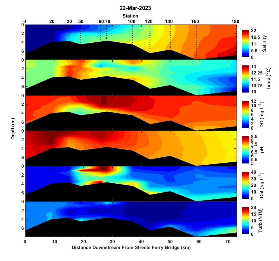
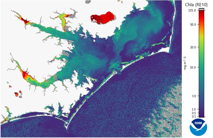
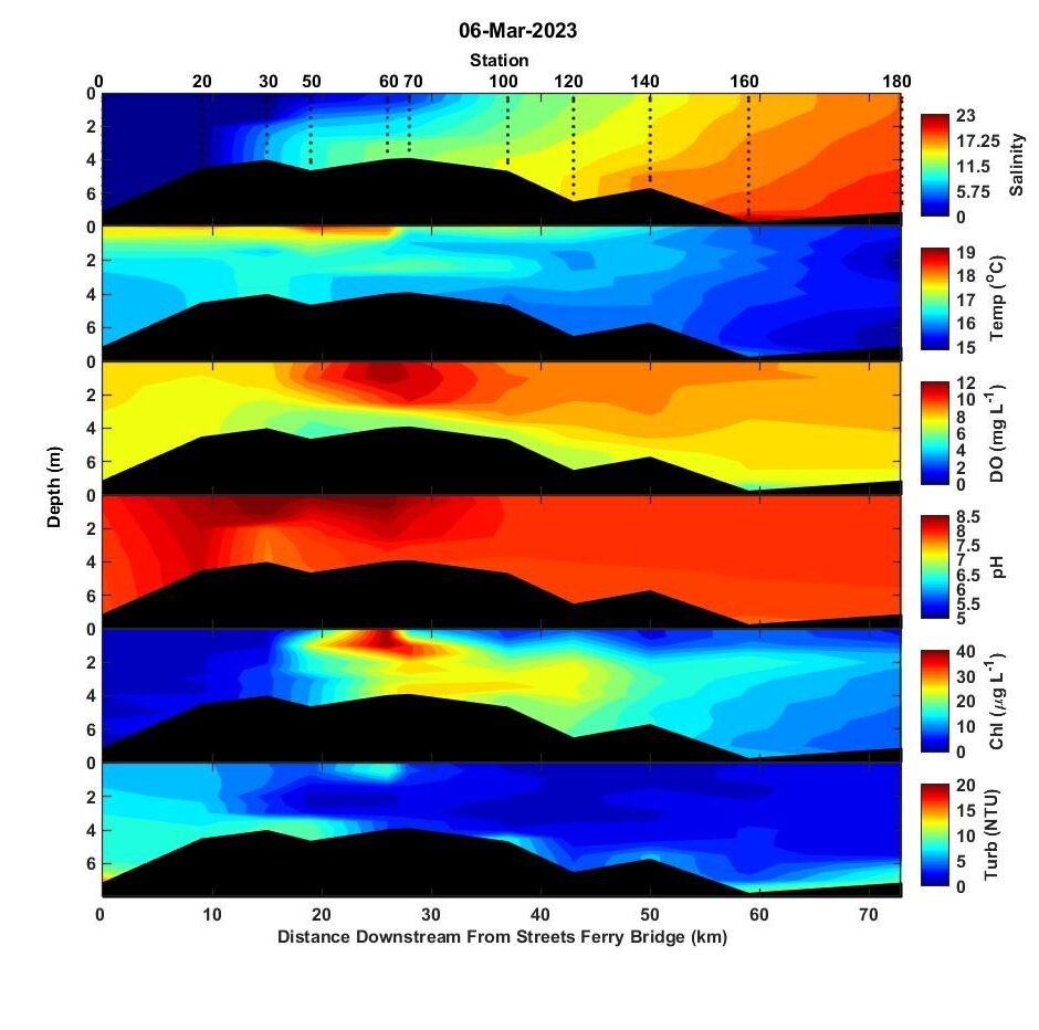
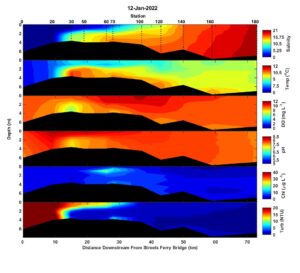
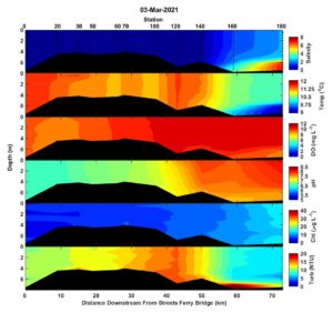
Not much has changed since the last report. A spring cold front cooled temperatures by about 5 degrees and now temperature are near their seasonal norm. River flow has been low all March at about half its seasonal norm. Salinity at the mouth was about 17 at the surface and above 20 at the bottom. The tip of the salt wedge is still upstream of New Bern (station 30). Supersaturated oxygen levels at stations 60 and 70 were produced by a dense surface bloom (chl > 40) at those stations. The bloom extended upstream as a subsurface bloom to above station 50. I looked at station 60 under the microscope and saw a near monoculture of the dinoflagellate Prorocentrum minimum, the same dinoflagellate species that’s been blooming in this region of the Neuse for the past two months. Colleagues, Drs. Rick Stumpf and Alexandria Hounshell, at NOAAs National Centers for Coastal Ocean Science have provided us a bird’s eye view of bloom with their chlorophyll a product derived from Copernicus Sentinel-3 satelite imagery. It shows the highly concentrated nature of the bloom with maximum biomass just where the estuary starts to widen and residence time increases. It also shows an extension of the bloom along the north shore of the estuary down stream to Beard Cr. P. minimum hasn’t been associated with fish kills or toxin production. If history is a good predictor, the P. minimum bloom will be gone in the next few weeks. The satellite derived chlorophyll also shows other co-occurring blooms in the Pamlico River, Pungo River, and on Lake Mattamuskeet. I wouldn’t be surprised if the Pamlico River and Pungo River blooms were also P. minimum. I’ve sampled Mattamuskeet recently and its bloom is a 50:50 mix of diatoms and cyanobacteria.
Best,
Nathan
Hi all,
Late winter has been unusually warm and water temperatures in the estuary are about 5 C warmer than normal. High salinity conditions are still in place with salinity near 20 at the estuary mouth. The tip of the salt wedge is still upstream of New Bern. No hypoxic bottom waters were observed. Super saturated oxygen conditions were observed near the surface at station 60 where high chlorophyll (>40 ug/L) indicated a bloom. The intense surface bloom at station 60 was part of a broad region with high (~25 ug/L) subsurface chlorophyll that stretched from station 50 to 120. Microscopic examination of station 60 surface water revealed a mix of the winter/spring bloom forming dinoflagellate, Prorocentrum minimum, and a Euglena sp. These are the same two species that were found blooming in the same area in February. Neither is thought to be problematic in regards to toxins and fish kills.
Best,
Nathan
Hi all,
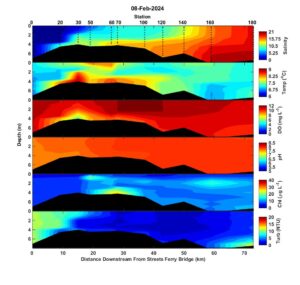
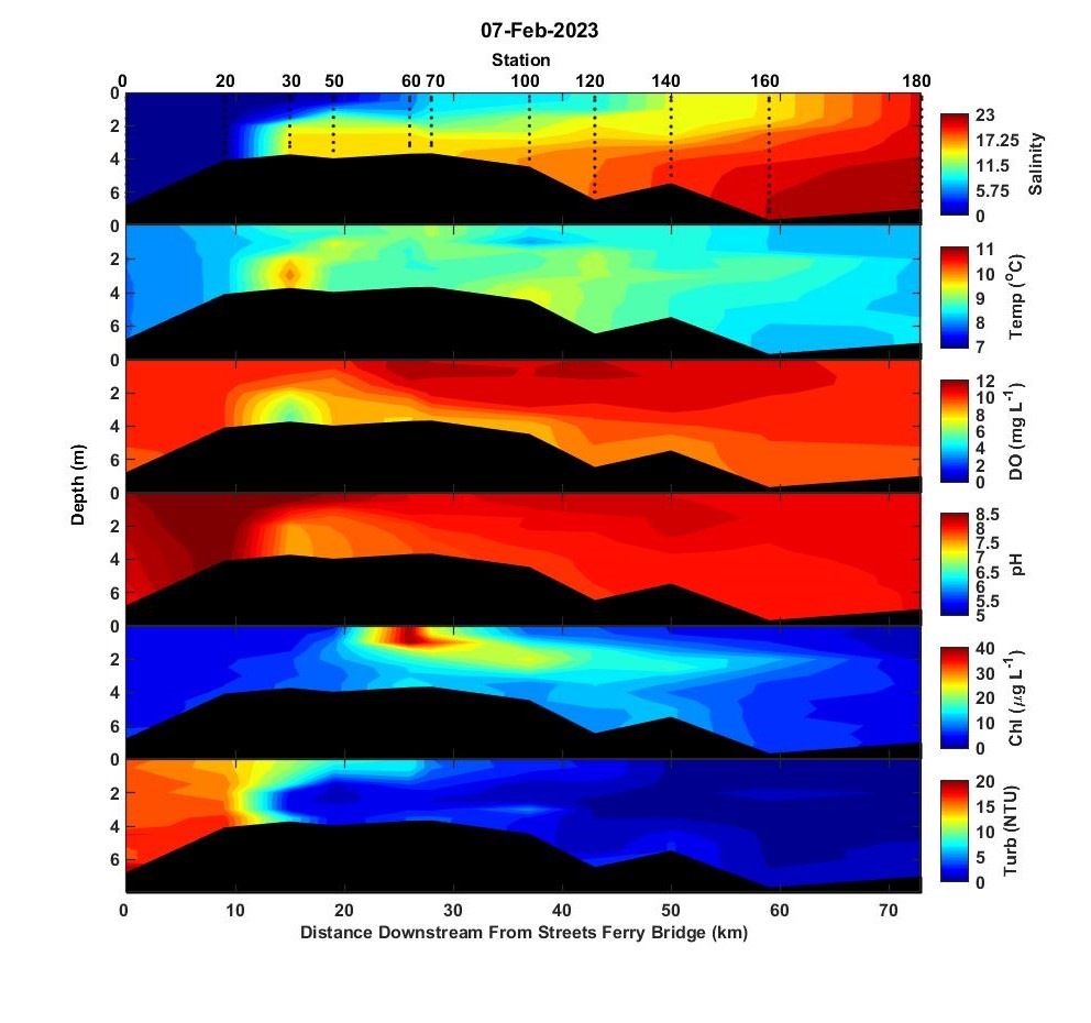
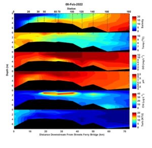
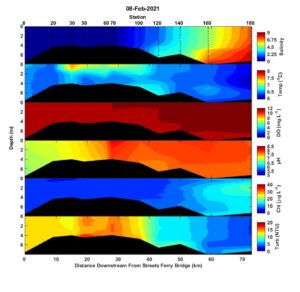
The Neuse River basin had several significant rainfall events prior to the 7 February sampling event and salinity in the upper estuary responded strongly. Surface salinity was < 5 downstream to station 60 and the tip of the salt wedge was between stations 20 and 30. Salinity in the lower estuary dropped about 5 units since January also. The freshwater pulse also caused high turbidity (>10 NTU) at the head of the estuary. Temperature was seasonably cool (8-10 C). Dissolved oxygen was well above levels required for the health of fish and other animals. However, the bottom water dissolved oxygen at station 30 was atypically low (~ 5 mg/L) for this time of year. Strong suppression of mixing caused by the > 10 salinity difference from the surface to bottom layer led to the oxygen sag even though respiration rates were surely very slow in at such cold water temperatures. A localized surface bloom at station 60 was caused primarily by very high densities of a Euglena sp. and secondarily by the dinoflagellate, Prorocentrum minimum. Neither have been linked to fish kills or other toxicity issues in North Carolina.
-Nathan
Hi all,
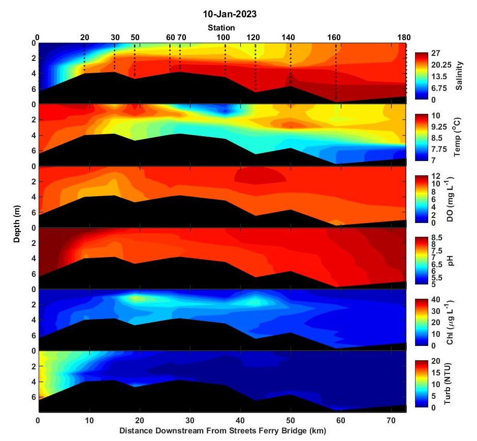
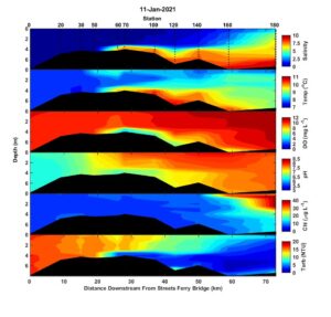
Here’s an update on the conditions during the first trip in 2023. The estuary was still extremely salty with surface salinity near the mouth well above 20. An oyster farmer friend measured a salinity of 28 in a creek near Bay River. We did have a little rain associated with a strong Christmas time cold front. The salt wedge still extends upstream of New Bern but higher flows have pushed the salt wedge downstream of Streets Ferry Bridge. The water is seasonably cold, < 10C. Dissolved oxygen conditions were normoxic throughout the estuary. Elevated turbidity (>10 NTU) at the head of the estuary likely resulted from higher flows. A subsurface chlorophyll maximum extended from station 30 to station 120 at ~1.5 m depth. Examination of station 50 surface water revealed numerous Prorocentrum minimum cells. Prorocentrum minimum is a shade adapted species that commonly forms subsurface maxima at low light levels. I bet that the observed subsurface chl-a maximum is the beginning of the nearly annual late winter/early spring bloom of Prorocentrum minimum. P. minimum isn’t known to produce toxins/ kill fish but it has been shown to cause problems with oysters. Fortunately, the area where it tends to bloom is too fresh for oysters anyway. The crew plans to be out again later this week and we’ll see how the bloom’s developed.
Best,
Nathan
2022
Hi all,
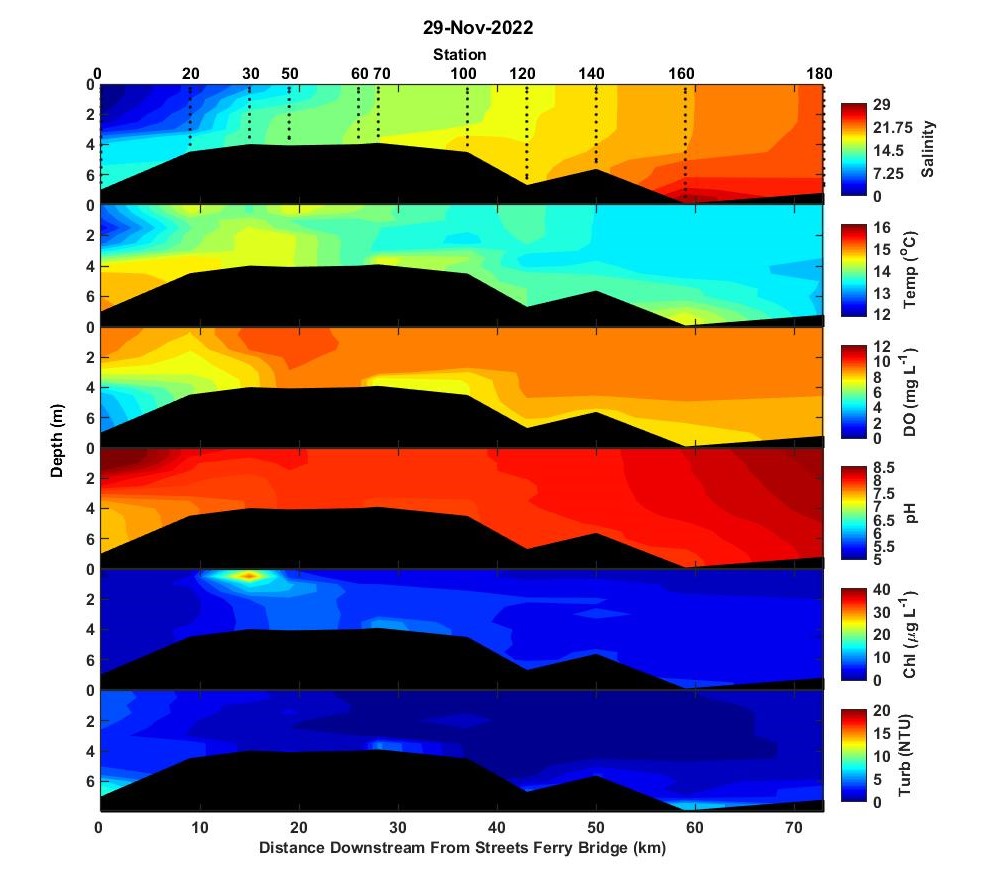
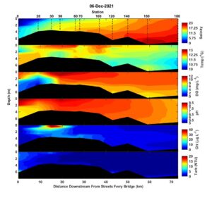
Overall, river flow during the fall has been very low and high salinity is still firmly in place. On 29 November, salinity still exceeded 20 in the lower parts of the estuary. The estuary was weakly stratified except in the upper estuary where the difference between surface and bottom salinity was approximately 10. At the head of the estuary at Streets Ferry Bridge (station 0), bottom water salinity set an all time ModMon record of 11.95 beating the previous record of 11.27 set in Dec. 2007. Dissolved oxygen was > 8 mg/L except in the highly stratified wates at Streets Ferry Bridge where bottom water dissolved oxygen was ~ 3 mg/L. Chlorophyll was generally less than 10 ug/L throughout the estuary with the exceptoin of a near surface maximum at station 30. Microscopic examination of station 30 surface water revealed a phytoplankton community dominated by the dinoflagellate, Prorocentrum minimum. P. minimum is the most common cool-weather, bloom-forming dinoflagellate in the Neuse. It’s not toxic and hasn’t been associated with fish kills. Turbidity was less than 5 NTU throughout the estuary. The monitoring crew is on the Neuse again today, so we’ll provide one more summary of conditions before the holiday break.
Best,
Nathan
Hi all,
Overall, river flow during the fall has been very low and high salinity is still firmly in place. On 29 November, salinity still exceeded 20 in the lower parts of the estuary. The estuary was weakly stratified except in the upper estuary where the difference between surface and bottom salinity was approximately 10. At the head of the estuary at Streets Ferry Bridge (station 0), bottom water salinity set an all-time ModMon record of 11.95 beating the previous record of 11.27 set in Dec. 2007. Dissolved oxygen was > 8 mg/L except in the highly stratified wates at Streets Ferry Bridge where bottom water dissolved oxygen was ~ 3 mg/L. Chlorophyll was generally less than 10 ug/L throughout the estuary with the exceptoin of a near surface maximum at station 30. Microscopic examination of station 30 surface water revealed a phytoplankton community dominated by the dinoflagellate, Prorocentrum minimum. P. minimum is the most common cool-weather, bloom-forming dinoflagellate in the Neuse. It’s not toxic and hasn’t been associated with fish kills. Turbidity was less than 5 NTU throughout the estuary. The monitoring crew is on the Neuse again today, so we’ll provide one more summary of conditions before the holiday break.
Best,
Nathan
Hi all,
So far, the second half of hurricane season had done little to end the low flow, high salinity conditions in the Neuse River Estuary.
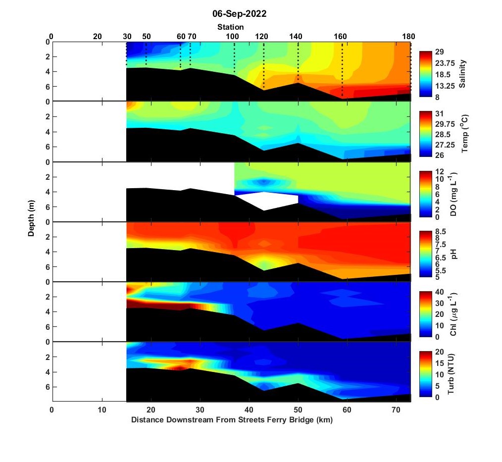
On Sep 6, surface water salinity at the mouth of the Neuse was 25 and bottom water salinity was about 29. Surface to bottom salinity differences were approximately 5 along the length of the estuary. The upper most stations were not accessible due to the railroad bridge being closed just above New Bern. Water temperatures were very warm, 26-30C. The bottom 2 meters of the water column were hypoxic from the mouth to station 100. The membrane on the dissolved oxygen probe failed after data from station 100 were collected. Phytoplankton biomass was generally less than 10 ug/L chlorophyll a except for a small zone of elevated (20-30 ug/L) chlorophyll a in surface waters and even higher chlorophyll a levels along the bottom from station 30 to station 70. Surface and bottom water samples from station 50 were microscopically examined and revealed that in both the surface and bottom there was a mixed assemblage of cryptophytes, dinoflagellates, diatoms, and a euglena. The euglena was likely the dominant species biomass-wise, followed by the dinoflagellates Levandarina fissa, and Scrippsiella trochoidea. The toxic dinoflagellate, Karlodinium veneficum, was also present, but at concentrations that are unlikely to cause fish kill problems (< 1000/mL). The main diatom was Leptocylindrus minimum.
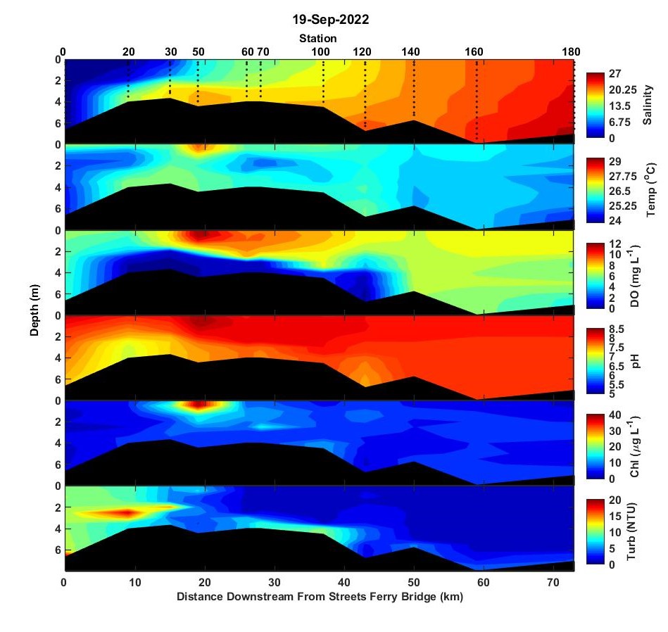
On 19 September 2022, the salinity regime was similar to that on 6 September but the lower estuary was less stratified. Water temperatures were ~25 C, cooler by 4-5 degrees compared to 6 September. At station 50, high surface water temperatures (~28 C) also coincided with high dissolved oxygen, chlorophyll a, and pH, all conditions indicative of a bloom. I think what we’re seeing here is that high light attenuation caused by a bloom increased the solar warming of the surface layer. Bottom water dissolved oxygen conditions downstream of station 140 were normoxic but hypoxic bottom water conditions extended from station 120 upstream to the tip of the salt wedge above station 20. Bottom waters at stations 20 and 30 were truly anoxic and smelled strongly of hydrogen sulfided. The high turbidity along the halocline at these stations is likely due to the formation of mineral precipitates as dissolved iron forms iron hydroxides when it meets oxygenated waters along the halocline. Microscopic examination of station 50 surface water showed that the bloom was dominated by the same euglena observed on 6 September, the dinoflagellate Levandarina fissa, and the autotrophic ciliate, Myrionecta rubra. None of these are know to produce toxins or cause fish kills.
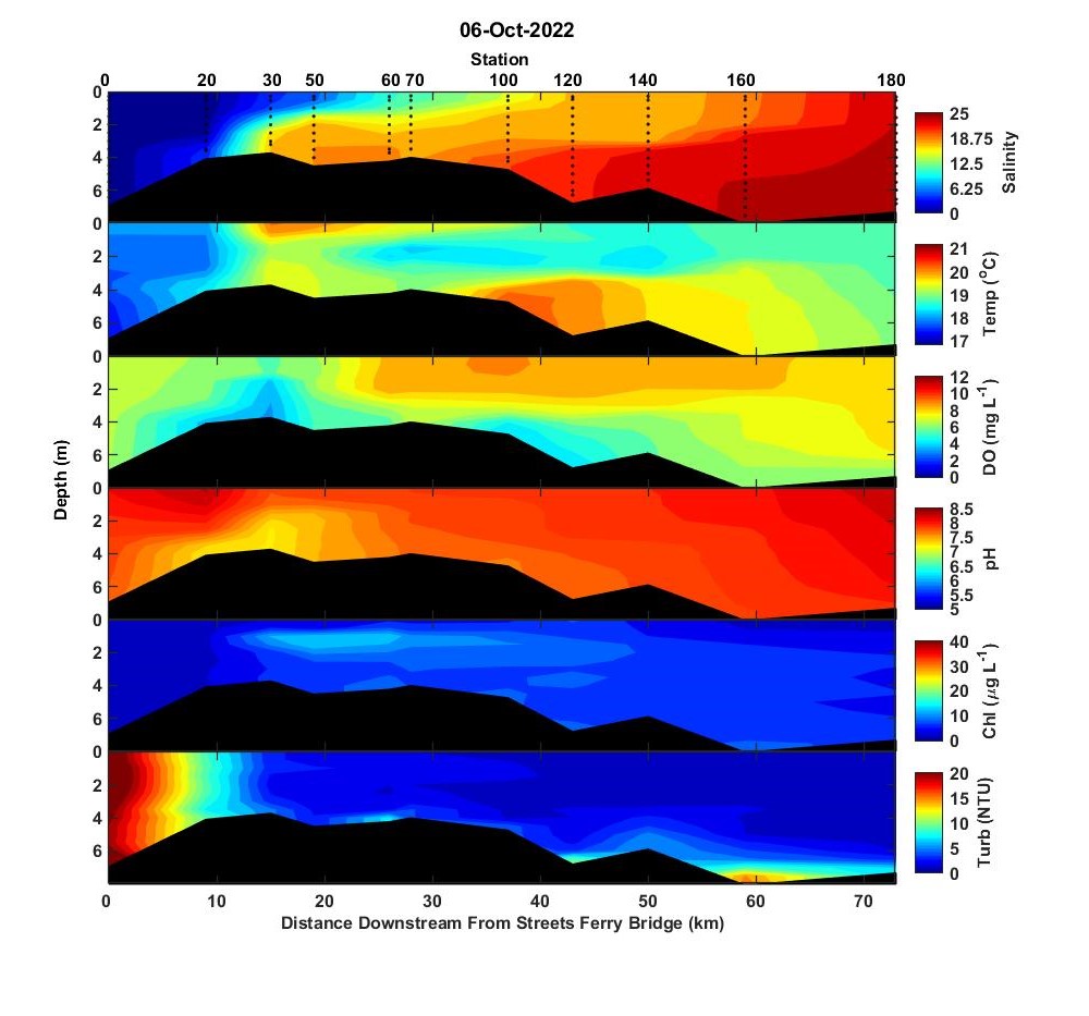
The Neuse River basin got several inches of rain in late September from Hurricane Ian. The resultant increased river flow decreased salinity a little. Surface salinity near the mouth was still > 20 and the salt wedge still extended upstream of New Bern. An early October cold front significantly cooled the water to less than 20C. Dissolved oxygen conditions were normoxic along the length of the estuary. There were no areas of high (>20 ug/L chlorophyll a) phytoplankton biomass observed. High turbidity (> 20 NTU) was observed at the most upstream station and probably reflects continued moderate river flows after Hurricane Ian.
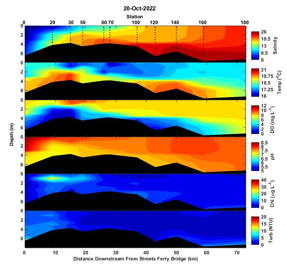
On 20 October, the tip of the salt wedge extended beyond our sampling stations. Bottom water salinity at station 0 (Streets Ferry Bridge) was 4.6. That’s in the 99th percentile of bottom water salinity at station 0. Despite cool water temperatures (<20 C), hypoxic conditions (< 2mg/L) occurred at stations 20 and 30. A subsurface zone of elevated biomass occurred at ~1 m depth from stations 20 to 50. Examination of surface water from station 20 showed that the community was dominated by Cryptomonas sp. All cryptomonads are generally considered nutritious phytoplankton that rarely cause any kind of habitat/water quality issues.
Take care,
Nathan

Hi all,
Flows on the Neuse River have increased some and have fluctuated around the seasonal norm since the beginning of August. The estuary is still really salty though. Surface water salinity at station 180 was 24.2, a 99% value for the ModMon dataset. The recent modest freshwater inputs haven’t changed that situation much but they are helping to maintain strong stratification in the upper parts of the estuary. From station 20 to 70, surface to bottom salinity differences are about 10 and the bottom waters are anoxic. The crew reported a strong sulfide smell and the water in sample bottles was bright orange from oxidation of free dissolved iron. There was a broad zone of elevated chlorophyll from station 30 to station 120. Throughout most of this zone, the chlorophyll maximum occurred at 1 to 2 m depth. At station 120, the maximum was at the surface. I examined samples from station 50 and 120. Station 120 had a typical mixed bag of cryptophytes, small diatoms, and several medium to large dinoflagellates including Scrippsiella trochoidea, Levandarina fissa (aka Gyrodinium instriatum), and Pheopolykrikos hartmannii. Station 50 was dominated by tiny, ~4 um diameter centric diatoms, but also had a few Levandarina fissa, cryptophytes, and small chlorophytes. Turbidity at the head of the estuary was about 7 NTU. At station 30 and 50 there was a zone of elevated bottom water turbidity with a subsurface turbidity maximum > 10 NTU along the pycnocline. This happens occasionally when the bottom waters are truly anoxic. I think it results from chemical precipitation of reduced iron as oxic and anoxic waters mix.
I hope everyone enjoys a safe Labor Day weekend.
-Nathan

Hi all,
The high flows of mid July were short lived and there was hardly any rainfall in the basin in the 2 weeks prior to sampling on 3 August. Conditions on August 3 were nearly identical to those on June 15. Surface salinity at station 60 was about 10 and surface salinity at the mouth was greater 20. Bottom water salinity at the mouth exceeded 25. Stratification was strong upstream near New Bern and moderate in the mid and lower estuary. Hypoxic conditions (< 2 mg/L) occurred in the upper estuary from station 20 to 50. The only area of high chlorophyll was the subsurface patch of high biomass that has apparently persisted at stations 30 and 50 all summer. The sample was again dominated by the dinoflagellate Levanderina fissa but it also contained a diverse mix of diatoms, cryptophytes, chlorophytes, and other dinoflagellates. None of the mixed assemblage are known to be problematic with regard to toxins and fish kills.
I hope everyone enjoys the rest of the summer and stays cool.
Best regards,
Nathan
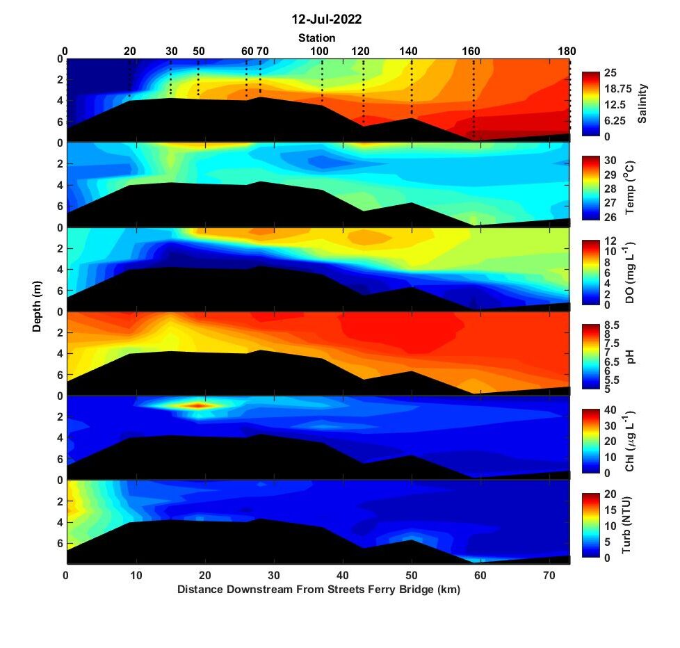
Prior to sampling on July 12, the Neuse basin had some substantial rain and river peaked on July 12 and 13 at about 4 times the seasonal average. On July 12, the main impact seen on the estuary was freshening of the upper estuary where low salinity water <5 extended downstream to stations 60 and 70. On the previous sampling on June 15, surface water salinity at these stations was ~10. High turbidity, 10 -15 NTU also resulted from the high flow. The estuary was stratified from New Bern to the mouth and bottom waters were hypoxic along that distance. As on June 15, there was a small subsurface maximum of chlorophyll a occurred along the pycnocline at stations 30 and 50. Microscopic examination of station 50 surface water showed the dominant organism was the same as on June 15, the dinoflagellate Levanderina fissa.
Hi all,
As I’m sure you’re all aware, it’s still really dry. The Neuse River flow is less than half its seasonal norm. Salinity is still high along the estuary and salinity is >20 in the surface waters near the mouth. The tip of the salt wedge is still upstream of New Bern. The estuary is moderately stratified with surface to bottom salinity differences of ~8 at station 30 to ~ 2 at station 180. Warm bottom water temperatures (> 25 C) and stratification promoted hypoxia (< 2 mg/L) from stations 30 to 120 and even the lower stations had bottom water DO < 4 mg/L. A small subsurface maximum of chlorophyll a occurred along the pycnocline at ~ 1.5 m depth at stations 30 and 50. Microscopic examination of station 50 surface water revealed a phytoplankton community dominated by the summer bloom forming dinoflagellate, Levandarina fissa (formerly known as Gyrodinium instriatum). Its not known to produce toxins and hasn’t been associated with fish kills.
-Nathan
Hi all,
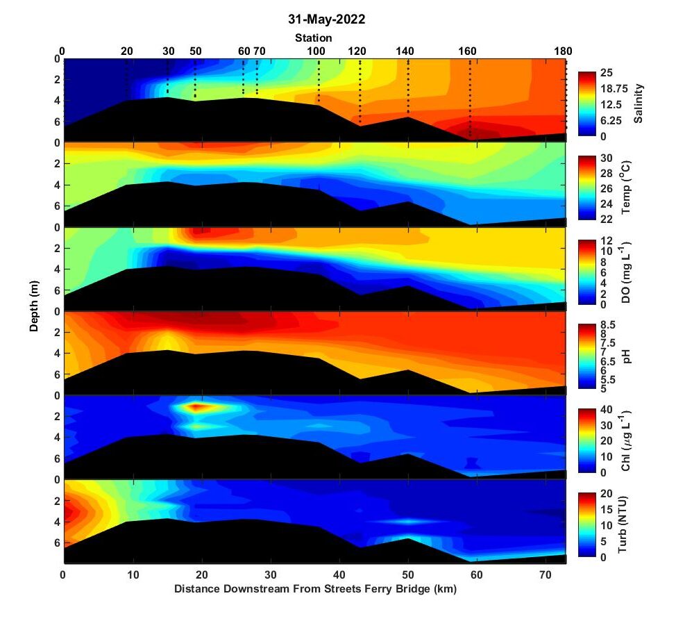
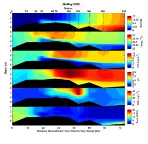
We finally got some rain in the basin on 26 May that sent river flows to nearly twice their seasonal norm. On May 31, the estuary was still really salty though. The salt wedge was upstream of New Bern and bottom water at New Bern (station 30) was ~ 10. Surface salinity at the mouth of the estuary was ~20. Water temperatures ranged from low 20s C in the bottom waters to nearly 30 C at the surface. The strong temperature gradient reinforced the vertical density gradient caused by salinity. Surface to bottom salinity differences ranged from about 10 upstream to 2 at the mouth. Hypoxic bottom water conditions were observed from the tip of the salt wedge at station 30 downstream to station 160. A subsurface zone of elevated chlorophyll (~40 ug/L) occurred at ~ 1 m depth at station 50. Microscopic observation of station 50 surface water indicated the phytoplankton community was dominated by small centric diatoms and cryptophytes. Generally, both small centric diatoms and cryptophytes are highly edible fuel for the estuarine food web. Elevated turbidity (15-20 NTU) at the freshwater head of the estuary is indicative of the elevated discharge conditions.
-Nathan
Hi all,
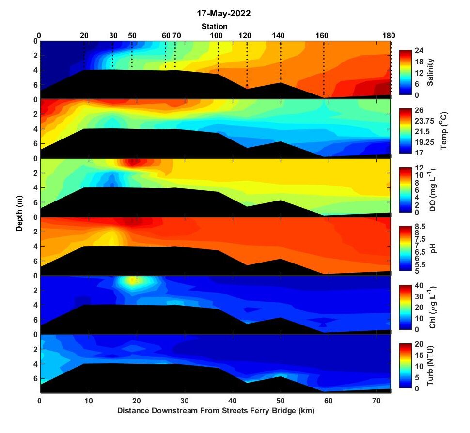
Conditions on 17 May 2022 were very similar to the previous sampling in April. The estuary is very salty with surface salinity almost 20 at the mouth. The tip of the salt wedge was upstream of New Bern which usually only happens during summer and fall drought. The estuary was normoxic with the exception of near the tip of the salt wedge at station 30 where dissolved oxygen was low < 4 mg/L but still sufficient for most estuarine fish. A small zone of elevated chlorophyll a (~25 ug/L) was observed at station 50. Microscopic analyses showed dominance by small centric diatoms and a few cryptophytes.
-Nathan
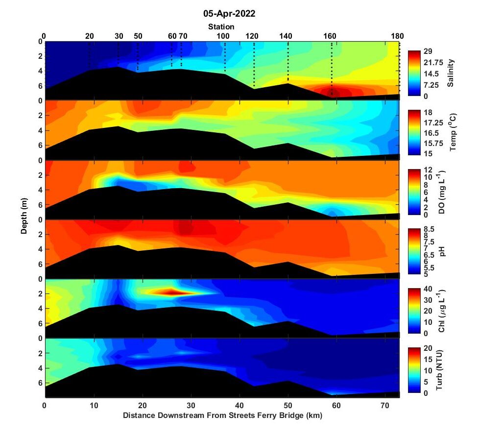
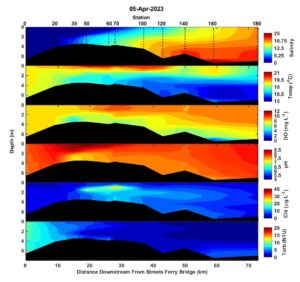
River flow has been below normal for most of the spring but there were some high flows in late March. On April 5, the upper estuary was freshened by those high flows with surface salinity < 5 downstream to station 70. Surface salinity at the mouth was ~18 which is unusually salty for spring. Despite cool water temperatures (< 20 C), low bottom water dissolved oxygen (< 4 mg/L) was observed in the upper estuary at stations 30 and 50 and within the high salinity intrusion of bottom water from the intercoastal waterway at station 160.
A subsurface zone of high chlorophyll a was observed along the pycnocline at ~ 2 m depth at stations 60 and 70. Microscopic analysis of surface water from station 60 showed a mixed bag of spring dinoflagellates, Prorocentrum minimum, Heterocapsa rotundata, Heterocapsa triquetra, small centric diatoms, and cryptophytes. These dominant species are not known to produce toxins. Karlodinium veneficum, a toxic fish killing dinoflagellate, was present in low numbers. Turbidity was highest (8-10 NTU) at the head of the estuary. Throughout the rest of the estuary turbidity mainly ranged from 2-3 NTU except at stations 60 and 70 within the zone of high phytoplankton biomass where turbidity was ~5 NTU.
-Nathan
Hi all,
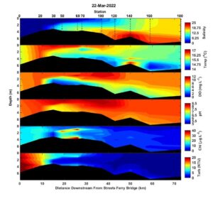
Since the last trip on 8 March, river flow has gone from about a quarter of the seasonal norm to well above average. The freshwater pulse resulted in a plume of highly turbid freshwater (>10 NTU) downstream to station 30, and strong salinity-based stratification from the tip of the saltwedge at station 30 to the mouth. Despite cool water temps (~15C), bottom water dissolved oxygen was depressed (2-4 mg/L) in the upper estuary from station 30 to station 70. The unusually salty and warm bottom water at station 140 is due to intrusion from the intercoastal waterway.
Two subsurface layers of elevated chlorophyll, one at 1-2 m and the other along the bottom, were observed at stations 50 and 60. The surface water sample from station 60 was examined microscopically and contained a mixed assemblage of the two dinoflagellates that have been blooming for the past 6 weeks, Prorocentrum minimum and Heterocapsa triquetra, and also several species of cryptophytes, and small diatoms. None of the major taxa were concerning, fish-kill/toxin wise.
Stay well,
– Nathan
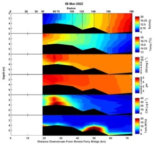
Hi all,
The crew managed to catch a brief break in northeast winds to do the March 8 run. The upper stations weren’t sampled due to steering problems on the boat. River flow for the weak prior to sampling was about 25% of the seasonal norm. As a result of the low flow, salinity is unusually high for late winter and ranged from 5 at station 50 to 20 in the bottom near the mouth. Vertical stratification was very weak due to prior wind mixing and low flow. There was a subsurface patch of high chlorophyll a at stations 60 and 70. I looked at the bottom water sample from station 70 and it was co-dominated by the dinoflagellates, Prorocentrum minimum and Heterocapsa triquetra. These are the two typical bloom winter/spring bloom formers in the Neuse and haven’t been shown to cause problems (e.g. toxins/fish kills etc.).
Stay well,
– Nathan
Hi all,
It was a calm day yesterday and the crew got out on the Neuse. We’ve had cold weather and several inches of rain/wintery mix in the past couple of weeks and the river flow is near its seasonal average. Water temperatures ranged from about 10C upstream to only about 6C at the mouth. The tip of the salt wedge was still upstream of New Bern, and the upper estuary from station 20 to station 120 was strongly stratified with surface to bottom salinity differences greater than 5. A pronounced subsurface maximum of chlorophyll with maximum concentrations near 40 ug/L occurred at depths ranging from 1.5 to 2 m from stations 30 to 140. The surface water sample from station 60 was dominated by the dinoflagellate Prorocentrum minimum which commonly forms these subsurface maxima in the Neuse, Chesapeake Bay, and other estuaries. The subsurface bloom also generated subsurface maxima of dissolved oxygen and even showed up as elevated turbidity.
We can expect the bloom to hang around through mid April before it mysteriously disappears. I say mysteriously because (as far as I know) the actual fate of all that biomass has never been completely worked out. Sediment trap studies have been conducted during blooms in the Neuse and the Chesapeake but they mainly catch diatoms even during dinoflagellate blooms. So, maybe the bloom is either passed up the food chain or eaten up by protist grazers within the microbial food web in the water column rather than settling to the sediments. It’s interesting, and probably has important implications for the role these late winter/ early spring dinoflagellate blooms play in summer hypoxia. If anybody sees any recent papers on this, I’d love to read them.
Stay well,
-Nathan
2021
Hi all,
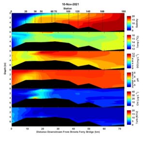
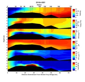
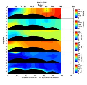
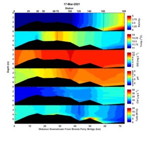
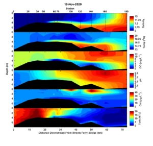
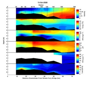
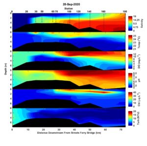
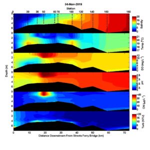
Hi all,Fall is here. The estuary has cooled significantly with temperatures ranging from 22-24 C. Although we’ve had some local rainfall along the coast, not much has fallen in the watershed and flows on the Neuse have been well below seasonal norms for the month prior to sampling on Oct. 11. Salinity is unusually high throughout the estuary. Station 180 wasn’t sampled due to high winds but salinity at station 160 was 17. Bottom water salinity was 3.4 at Streets Ferry Bridge (station 0), and that’s in the 97th percentile of measurements made at the head of the estuary. Vertically, strong winds resulted in a well-mixed estuary and there were no areas of bottom water hypoxia. Chlorophyll was low (<10 ug/L) throughout the estuary with the exception of a small zone of elevated chlorophyll (~ 25 ug/L) at the surface at station 20. Microscopic examination of station 20 surface waters showed the high biomass was caused by the marine dinoflagellate, Levandarina instriatum. This dinoflagellate species commonly blooms in the Neuse during warmer months. It isn’t a known toxin producer and hasn’t been associated with fish kills. -Nathan
2020
2019
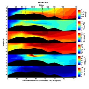
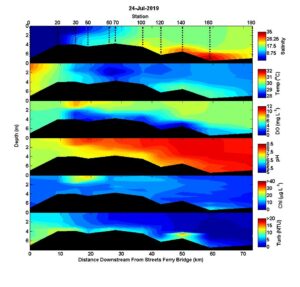
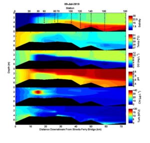
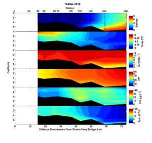
Hi all,
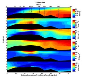
I’m a little behind but here are the results from the last Neuse run on 9 July. It’s crazy how things have changed since spring when the estuary was basically a river. Salinities in the bottom waters of the lower estuary are as high as I remember seeing. The only other time that bottom waters at 180 have been this high was on 5 Oct 2002. Neuse river flows do not indicate that we are in as significant of a drought as in 2002. So, I think something on the ocean-side of the estuary might be playing a role in the high salinities and plan to see what our physical oceanographers think. The estuary was strongly stratified from New Bern to the mouth. Bottom waters were anoxic along much of the transect as evidenced by a strong sulfide smell. The crew will be out again next week.
Best,
Nathan
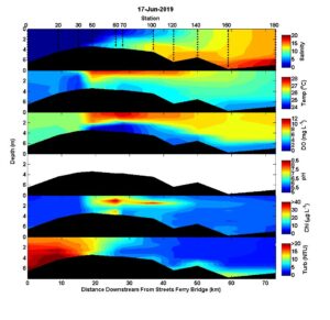
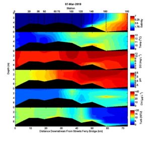
Hi all,
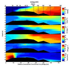
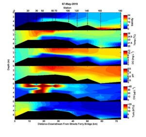
Salinity in the lower estuary is average for this time of year but the upstream section is a little fresher than normal. The basin saw quite a bit or rain in the second week of June and river flows are about four times higher than the seasonal average. The salt wedge penetrated upstream to station 50 just downstream of the HWY 17 bridge. Bottom water dissolved oxygen was low from the tip of the salt wedge through the length of the estuary but was only below 2 mg/L (acutely lethal to fish) at stations 50-70. A subsurface peak in chlorophyll a at about 1 meter depth occurred from stations 60 -100. Microscopic examination of the surface water sample from station 60S revealed high concentrations of the dinoflagellate, Gyrodinium instriatum. This dinoflagellate is a common bloom former during the warmer months in the Neuse and is not known to produce toxins or negative food web related impacts. Photosynthesis produced a zone of supersaturated dissolved oxygen at the stations with high chlorophyll. pH data are not shown due to probe failure.
Happy 25th Birthday ModMon!
Hi all,
For two and a half decades, ModMon has provided valuable information on water quality and habitat conditions in the Neuse River Estuary and Pamlico Sound. These data are crucial for evaluating how conditions are changing in response to human and climatic pressures. ModMon has also served as a platform to support research projects aimed at figuring out how estuaries work from ecological, geological, physical, and biogeochemical perspectives.
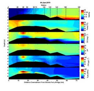
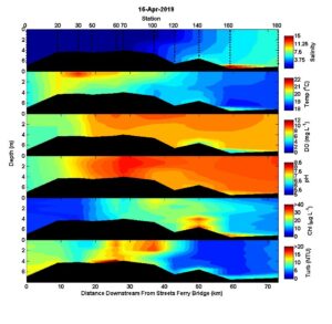
Conditions on 4 June 2019 were pretty typical for this time of year. Salinities ranged from zero above New Bern to a maximum of about 15 in the bottom waters near the mouth. Stratification was not particularly intense except at station 160 which was influenced by saltier bottom water likely from the Intracoastal Waterway. Hypoxic conditions occurred throughout most of the length of the estuary but were confined to a thin, ~1 m thick, layer near the bottom. A zone of high DO, high pH, and high chlorophyll a was observed at station 30 near New Bern. Microscopic examination of surface waters from station 30 revealed a high concentration of cryptophytes that are generally good food for higher trophic levels, and don’t cause problems.
Best,
Nathan
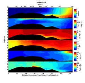
Hi all,
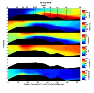
A couple of weeks without rain and the estuary is looking almost normal. The salt wedge is at New Bern and surface water salinity near the mouth was about 10. Most of the estuary was strongly stratified and bottom waters were hypoxic from stations 60 to 160. There was a peak in DO at station 50 that was likely due to high phytoplankton production. Microscopic observation of the station 50 surface sample showed a high concentration of small (3-5 um) centric diatoms. Chlorophyll data are not shown due to a failed probe. During the previous trip on 7 May, the chlorophyll probe of the YSI data sonde started to malfunction but the malfunction was not noticed until this trip on 21 May 2019. The bloom level chlorophyll a concentrations observed at station 50 on 7 were an artifact of this malfunction. The probe has been replaced and in vivo chlorophyll a data from both dates have been flagged in the data set.
A fish kill was observed a few days following this trip on 21 May, but no dead fish were noticed during a boat run from New Bern to station 100 on yesterday, 28 May. Based on the reports that I saw, the dead fish were mostly menhaden and had sores consistent with ulcerative mycosis caused by Aphanomyces invadans. This fungus is most virulent when salinities are low and temperatures are in the low to mid 20’s C; conditions observed during the fish kill. Fish that are already stressed, e.g. due to hypoxia, are more likely to suffer from the infection. I’ve attached a couple good papers for those interested.
Best,
Nathan
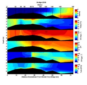
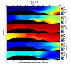
Hi all,
The Neuse is an estuary again, a strongly salinity, stratified estuary with hypoxic bottom waters. The hypoxic zone stretched from just downstream of New Bern to the mouth. A zone of high chlorophyll with a subsurface maximum at ~1 m depth was detected from stations 20 to 70. Microscopic examination of surface waters from station 50 revealed a community dominated by freshwater diatoms, primarily Aulacoseira.
Until the next trip,
Nathan
Hi all,
Not much has changed on the Neuse. It’s still much fresher than normal. There is a small bolus of high salinity bottom water at station 160, but that’s likely intruding from the intercoastal waterway. High chlorophyll (~30 ug/L) and turbidity occurred near the surface at station 100, and microscopy identified high concentrations of the diatom Aulacoseira sp., and a high concentrations of several cryptophyte species. These phytoplankton are non-toxic and considered “good” phytoplankton that tend to contribute energy to higher trophic levels.
Best regards,
Nathan Hall
Hi all,
For the first time since Hurricane Florence, the estuary has some salt upstream of the bend at Cherry Point (station 120). The lower estuary is moderately stratified but the water is still cool and dissolved oxygen is > 8 mg/L throughout the estuary. There was a front between stations 60 and 70 with strong downstream gradients of temperature, pH, Chlorophyll fluorescence, and a spike in turbidity at station 70.
Best,
Nathan
Hi all,
With flows just above average, the Neuse is starting to look more like an estuary, a really fresh estuary but at least with some salt at all the lower stations. Moderate chlorophyll values of ~20 were patchily distributed throughout the mid/lower estuary.
Best regards,
Nathan
Hi all,
Unbelievably, the estuary is fresher now than what we measured ten days after Hurricane Florence. Temperatures are cool and DO is high throughout the estuary. chl-a was generally les than 20 throughout the estuary except for a thin aggregation along the pycnocline at the lower stations. The dinoflagellate, Prorocentrum minimum, is famous for this and has been abundant for the last few trips.
Best,
Nathan
Hi all,
It’s still really fresh and the bloom downstream has gotten more dense. I looked at a sample from station 180S and the bloom is mostly Heterocapsa triquetra with lesser abundances of Prorocentrum minimum and Heterocapsa rotundata. Again, these dinoflagellates don’t typically cause problems.
Best,
Nathan
Hi all,
The Neuse is still really fresh and it looks like the winter/spring bloom may be starting near the mouth. I looked at station 180 surface waters and the phytoplankton biomass was dominated by the dinoflagellate, Heterocapsa triquetra. There were also a bunch of cryptophytes, and small diatoms; nothing to worry about toxin or fish kill wise.
Best,
Nathan
2018
Hi all,
The Neuse River Estuary continues to be fresher than normal but the salt wedge has crept back up to near the HWY 17 bridge. Temperatures have cooled a little since late November. Dissolved oxygen is greater than 9 mg/L throughout the estuary with the exception of bottom waters at stations 60 and 70 where oxygen levels were around 7 mg/L. Turbidity was generally less than 10 NTU throughout the estuary but was approximately 10 near the surface at station 120 and along the bottom in the lower estuary. There were no strong peaks in chlorophyll.
Happy Holidays!
Nathan
Hi all,
With all the rain in the past two weeks the estuary is really fresh. Salinity at the surface near the mouth was only 6. The estuary has also cooled a lot with the latest cold fronts. Dissolved oxygen was high ((8 – 12 mg/L)and chlorophyll levels were low to moderate (< 20 ug/L) throughout the estuary.
Best,
Nathan
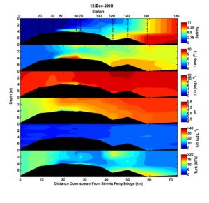
Hi all,
Salinity is slowly rising with measureable salinity intruding in the bottom waters as far upstream as station 50 and surface water salinity near 10 at station 180 near the mouth. Water temperature cooled by 5-6 degrees since mid October and there were no stations with hypoxic bottom water conditions. Phytoplankton biomass as measured by chlorophyll fluorescence was highest near the surface at stations 120 and 140. I looked at surface water from station 120 under the microscope and saw mainly small centric diatoms and small cryptophytes. I didn’t see any known harmful algal bloom species.
Stay tuned.
Nathan
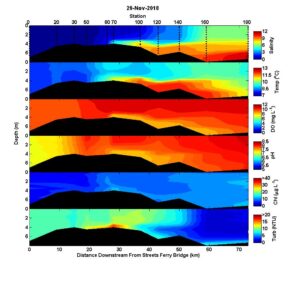
Hi all,
Here are the latest conditions on the Neuse River Estuary. It’s still much fresher than normal but saltier than a couple weeks ago. Water temperatures have cooled by 3 or 4 degrees and dissolved oxygen has increased throughout the estuary. Bottom water hypoxia was only observed at stations 140 and 160, and then only just above the bottom.
Best,
Nathan
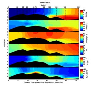
Hi all,
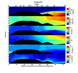
Here are the latest conditions. River flows are slowing down and the salt wedge has crept back up to near New Bern despite very low surface salinities. Stratification is strong and dissolved oxygen is basically zero in the bottom waters from New Bern to the mouth. Residence time is increasing in the mid estuary to the point that chlorophyll levels are starting to rebound after having been flushed out by Florence.
Best,
Nathan
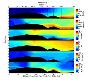
Hi all,
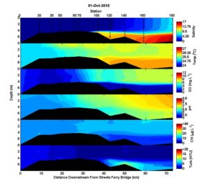
The Neuse was sampled again yesterday. It looks very similar to last week with hypoxic river water entering the estuary and bottom water hypoxia and strong salinity stratification in the lower estuary. pH values of the river water have increased from 5.5 to about 6.5. No algal blooms were observed. Another trip is planned for next week.
Best,
Nathan
Hi all,
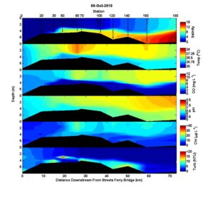
Not surprisingly, most of the estuary is completely fresh after parts of the watershed received 20+ inches of rain. Surface salinity near the mouth at station 180 were about 2. Some folks have asked when the last time salinity got this low at station 180. Surface salinity at the mouth was actually a little lower after Matthew in 2016, and was likely lower after Floyd in 1999 (don’t know for sure because station 180 wasn’t sampled after Floyd). Bottom waters near the mouth are still high. The intense stratification is accompanied by bottom water hypoxia at the downstream stations. All the upstream stations also have relatively low oxygen levels due to decomposition of all the organic matter that has been washed out of the watershed. The upstream pH values were also among the lowest on reThe field crew noted that the whole river smelled bad. There were no phytoplankton blooms.
Best,
Nathan